Bridges, Fords & Flooding
- Dowlish Wake, nestling here in this Somerset hidden valley, with its cider mill and apples.....
- Rolling hills, ploughed fields, combes, streams, ancient woodland.....
- Family-run farms, thatched cottages, a charming inn, the old trade route over the packhorse bridge...... and sometimes it rains.
Streams and Brooks
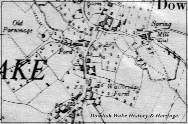
Dowlish Brook has its beginnings in streams flowing down from the slopes of Windwhistle ridge. Here springs rise to form Wall Brook and Stretford Water. These form 'Dowlish Brook' near the village of Dowlish Wake, before flowing under the packhorse bridge, having crossed under or over the ford there. Other un-named streams originate from springs near Bonner's Leaze and Cudworth.
They go on to join together near Lower Wallbridge Farm, flowing to the left of the Cider mill. This then passes close to the Old Parsonage, before joining the Dowlish Brook near Bryants. From here it flows through Dowlish Ford and into the River Isle at Donyatt then onto the River Parrett.
The tributaries, Wall Brook and Stretford Water, have their origin near Cudworth, Ludney, Lower and Higher Chillington. On their descent, they once formed a mill race, providing waterpower for Dowlish Wake flour mill in Mill Lane.
Ancient Trade Route
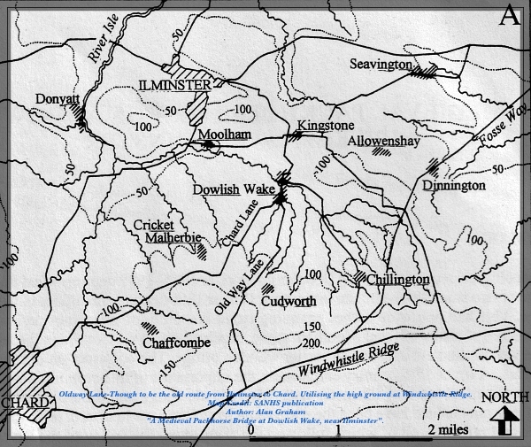
The ancient parish of Dowlish Wake, previously known as East Dowlish, is fortunate to have retained its medieval packhorse bridge, and its roadway alongside it. The fact that it continued to justify alterations, parts of it having been rebuilt, is evidence that this village continued to be part of a valuable trade route. Oldway Lane thought to connect with the Fosse Way at Axminster and north through Ilchester. East Dowlish in the past would have seen passing through its village, pedlars and packmen their horses loaded with Somerset Wool, at other times heavy traffic up to the old ridgeway Windwhistle and the great Saint White Down Fair, this established in 1361. A major fair, being located on high ground with roads giving access to Devon, Dorset, London and drovers herding cattle from as far away as Glamorgan, Wales.
The width of the bridge, one horse wide, and its low sides walls, designed to accommodate bulky panniers hanging on each side of each of the long line of pack horses. A common sight at one time, a 'train' of horses, travelling up over the bridge, avoiding the muddy stream, each heavily laden, the leader ringing his warning bell. The bridge too, a crossing place over the brook by foot, with additionally the wider roadway ford for carts and other livestock.
The Packhorse Bridge & Ford-Crossings
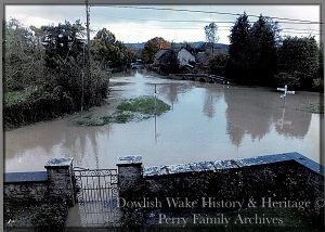
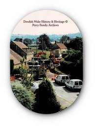
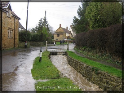
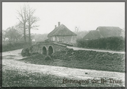
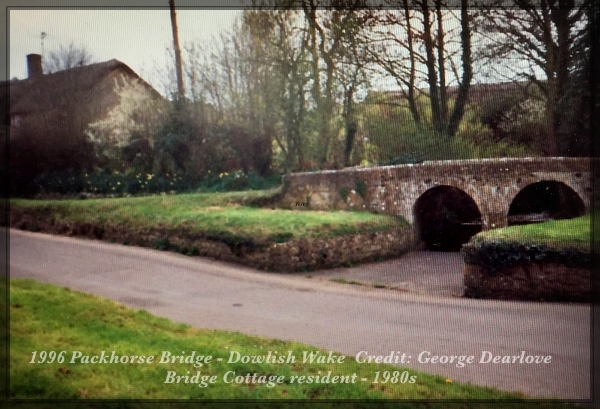
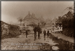
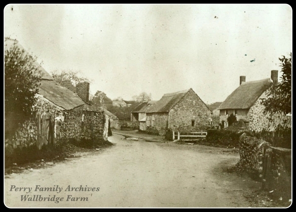
The Packhorse Bridge in ancient times, wooden, replaced in the 14th or 15th century with a stone bridge. This late medieval bridge having two wide arches, each span measuring around 12 feet. Sometime after 1700 this was rebuilt after either collapsing or been unstable and demolished. This third bridge however had two significantly smaller semi-circular arches. Which in itself is thought to have contributed to the flooding for many years afterwards, this of course before the relief work of 1997. Back then the ford further up Main Street by Wallbridge Farm, the 'Higher Ford', muddy and dangerous, this area illustrated in the photo below. Here the streams rushed past what was once Wallbridge farm and its buildings. Now Lower Wallbridge Farm, Old Wallbridge & Spring Cottage. For all things Archaeological concerning Dowlish Wake Bridge, visit: "A Medieval packhorse bridge at Dowlish Wake, near Ilminster" a Sanhs publication online at sanhs.org. Clear descriptive interesting history of the Dowlish Wake Packhorse Bridge. Author: Alan Graham.
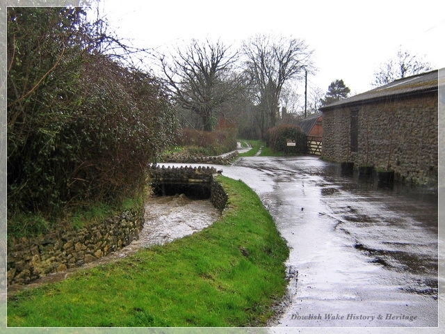
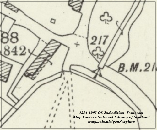
This upper ford, in the middle of the village, in Main Street near what used to be Wallbridge Farm often caused problems. Here the Wallbrook, an open stream flooded and muddied the lane, this ford permanently wet and muddy. The farms creating many journeys to and fro though the village here, carts and later vehicles negotiating the ford with its slippy conditions. In fact in the spring of 1942, the parish council minutes, recorded on different occasions 'three army motorcyclists, and even a heavy lorry, negotiating the ford, had run off the road into the stream, one of them knocking down the danger sign'. The chairman, Mr Pring, proposed requesting the Highways Committee surveyor have a white rail be fitted, along with extra danger signs placed across the stream at this point. Various remedies over the years, but it would not be until 1997 that significant flood relief works were carried out, removing the need for a ford. The Wallbrook now contained, and flowing through a culvert under the road, thence down a walled channel alongside the road.
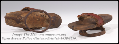
Of note in the older photograph above is the footpath raised enabling passage to villagers in all but the most extreme weather. Otherwise to escape lanes and paths deep in sticky clay, mud and water, villagers could avail themselves of outdoor protective footwear. Village shoemakers fashioning and supplying clogs or wooden/metal platform 'pattens', a sort of 'overshoe' the thick sole inches high. These created a raised platform, held in place with leather or cloth straps, the wearer avoiding animal dung, mud and floodwater. Some styles worn as over-shoes.
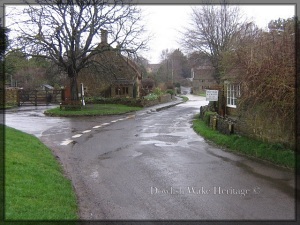
Returning now to the Packhorse bridge and its ford; 'Lower Ford', the position of the actual packhorse bridge and its footpath has always been set back, on the downstream side of the road. The ford not always having a solid surface but once rutted with mud. In dry weather the ford dry, the Dowlish Brook running in a culvert under the road. There have however, been times, with exceptional weather, when both bridge and ford impassible for foot or vehicle. A detour long and tedious.
Normally, the bridge and ford joining the two halves of Dowlish Wake and having been in use for centuries. The photograph below shows this ford with Wayside and Bridge cottages on the right, Higher Farmhouse on the left.
Many a time, locals have rescued occupants from vehicles that were submerged alongside the arches of the Packhorse Bridge. Villagers in properties near the bridge have found themselves cut-off at times and occupants trapped in upstairs rooms. A regular occurrence at one time, in fact, one year, around 1915, Wayside Cottage had bread delivered via a bedroom window. The baker balancing the loaves on his oven-shovel!
The packhorse bridge ford-crossing is close to Perry's Cider Mill, the roadway here gives access to Perry's Orchard Carpark, footpaths, fields, and properties, 'Stonesmead' and 'The Old Parsonage'. Flooding here can still restrict foot and vehicle access to these latter properties.
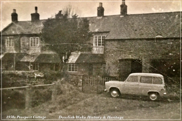
At the top end of the village in Cudworth Lane there was once a third ford, replaced by a bridge, date unknown. This thought to have been Oldway Lane. This ford took water, which mostly meandered down from Bonner Leaze. However at other times the old Carpenters Shop [Prospect Cottage] and Rose Cottage could be flooded. Its the spot also that the carpenter in Prospect Cottage used as a Saw Pit.
The little lane at the side of Prospect Cottage, older residents called 'Kings Highway', a muddy cinder track. Vestry minutes convey many requests to asphalt it.
Stretford Lane
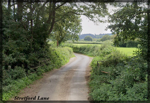
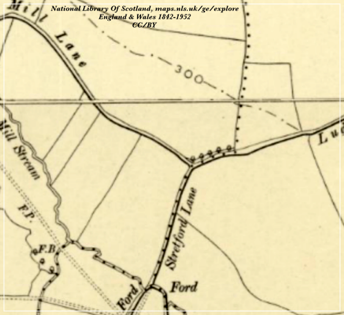
Another ford-crossing out of the village, but on the edge of the parish boundary was Stretford Lane, near to Dowlish Lane, Mill Lane and Oldway Lane [the latter track now abandoned]. The name Stretford meaning 'street on a ford'. The roadway here said to have led to the chapel of St Reigne/Rayn in the 13th Century. Part of the Fosse Way, linking Dinnington with Windwhistle ridge, an alternative to Oldway Lane and Ludney Lane, in ancient times.
The ford here very often un-passable with deep flood water causing a nuisance for many a year. Stretford Water floods Stretford lane, fields and footpaths. Disruptive for Chillington, Cudworth and Dowlish farms and their farm labourers, as emphasised in a newspaper account of 1883. Mr Duke, local landowner, seeking the building of a bridge, complaining to the 'Ilminster Highway Board'. Requesting a solution to the problem which had been before the council for some 30 or 40 years. This like other attempts to alleviate the flood problem fell by the wayside, disputes around which Highway Board would finance the project, indeed which Board was libel was never clarified.
Unemployment Scheme
In fact it was not until much later, in 1923, under a scheme to relieve the high unemployment in Britain at that time, that a flood alleviation scheme at Stretford Water was agreed. Crewkerne, Chard and Ilminster approved a schemes at a total sum of some £26,500. It was expected that the project would absorb practically all the unemployed in their districts. The Stretford Water Scheme, approved at Chard RD Council level, went ahead. With the men paid 30 shillings a week, the project costing £670.
Reasons for flooding
Flooding even at average rainfall challenged drains, culverts and gullies which can be silted up. Storms bring tree debris which build-up blocking these drains, gullies and ditches. Flooding caused by abnormal rainfall, is aggravated by run-off from the land. The aftermath of heavy downpours of rain falling on already soaked earth. This volume of water is then unable to drain away through the existing drainage system. There is of course the natural layout of the land with water pouring downhill from Windwhistle Ridge, at times a volume of water more significant than the drains and culverts can cope with, creating 'road rivers' in our lanes.
![A stranded cart in flooded ford, Dowlish Wake Lower Farm with cart in flooded ford. [Dower House]](/dowlish-wake-heritage/assets/images/yesteryear-dowlish-wake-lowe)
Action
The Church and Manor house had clearly been built on higher ground. Otherwise, lower down, the problem of flooding continued year after year. The village vestry parish meeting minutes, clear illustration of the ongoing flooding problems. The Chard & Ilminster News, in November 1910, with a column heading; 'Dangerous Fords', reported on a meeting of the Chard Rural District Council. The county surveyor, Mr R Stephens, warned generally of such problems in his area, dangerous crossings created by floodwater on principle roads. Idealy he would like, he said to build a bridge every year. He considered Dowlish Wake's problem one of the three 'worst places' on his patch. However cost was the problem the chairman said. Major Speke, proactive in seeking to alleviate the situation of repeated flooding’s in Dowlish Wake, quickly offered to contribute to any Dowlish Wake improvement and stated he wanted 'the matter dealt with'. This meeting closed, no work ordered and the vestry meeting minutes continued to bring the problem to the table.
It was not until 1997, the formation of two additional arches to the bridge and it's rebuilding plus major work addressing the Upper ford in Main Street, that the long awaited improvements went ahead.
Photo Credit; George Dearlove, Former villager living in Bridge Cottage from 1980s.
Archaeological Detail: "A Medieval packhorse bridge at Dowlish Wake, near Ilminster" a Sanhs publication online at sanhs.org. Clear descriptive history of the Dowlish Wake Packhorse Bridge. Author: Alan Graham.
Mr Pring & Three Army Motorcycles Accident; Minutes of Dowlish Wake annual parish meeting, 23rd March 1942. Dowlish Wake Village Archives
Pattens. Did you know there is a 'Worshipful Company of Pattenmakers' awarded a Royal Charter in 1670.see 'footwear' pattenmakers.co.uk
The great fair at Saint White Down: page 24, Old Somerset Customs, Markets and Fairs, Muriel Walker & Mary Gryspeedt.
Online newspaper records; The British Newspaper Archive – Find my past Subscription website. Findmypast.co.uk
1883 Mr Duke - The Western Gazette, Friday, June 15th, 1883.
1910 Major Speke - The Chard & Ilminster News, November 1910
1923 Unemployment Scheme - Taunton Courier January 24th, 1923.
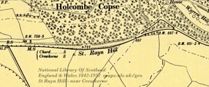
St Rayn's Chapel: see online british-history.ac.uk Parishes: Chillington
The chapel itself a mystery but remembered on the A30 as St Rayn Hill.
[adjoining Mangle Cave Hill on route to Crewkerne.
![Remembering the floods at Dowlish Wake - newspaper cutting Ilminster Fire Service, Ex-Fire Officer - John Coles [newspaper cutting]](/dowlish-wake-heritage/assets/images/newspaper-clipping-date-unkn)
